About the project
Planning and Development
In terms of planning, the strategic and national need for the proposed road development is supported within a number of national, regional, and local policy documents and plans including:
European Policy Context
- The Trans-European Transport Network (TEN-T).
National Policy Context
- The National Spatial Strategy 2002 – 2020;
- Ireland 2040 Our Plan. Draft National Planning Framework (NPF)
- National Development Plan 2007-2013;
- Smarter Travel: A Sustainable Transport Future 2009 – 2020;
- Investing In Our Transport Future: A Strategic Framework For Investment in Land Transport;
- Building on Recovery – Infrastructure and Capital Investment 2016 – 2021;
- Road Safety Authority Road Safety Strategy 2013 – 2020;
- A Programme for a Partnership Government – May 2016.
Regional Policy Context
- Regional Planning Guidelines for the West Region, Northern & Western Regional Assembly (formally West Regional Authority) 2010-2022;
- Western Development Commission Policies.
Local Policy Context
- Roscommon County Development Plan 2014 – 2020.
Transport Infrastructure Ireland’s Studies
- National Roads Needs Study.
General Description of the Proposed Development
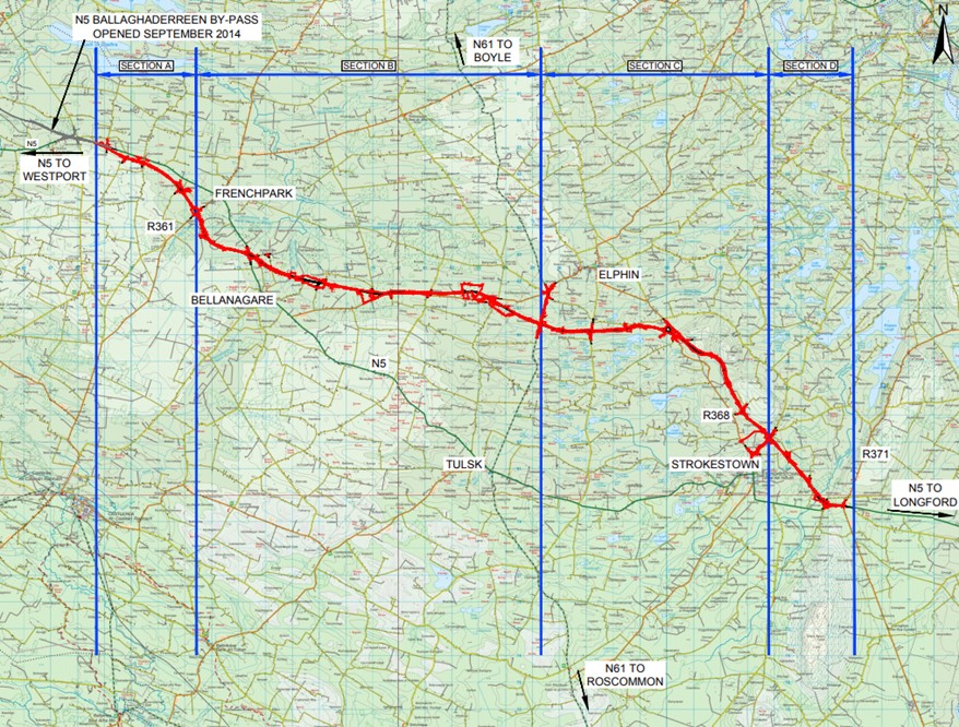
The N5 Ballaghaderreen to Scramoge Road Scheme comprises of a Type 1 Single Carriageway cross section, consisting of two 3.65m wide lanes and associated hard shoulders, road verges, earthworks and drainage ditches, approximately 33.4km in length. The alignment commences east of Ballaghaderreen at a tie-in with the newly constructed N5 Ballaghaderreen Bypass and continues eastwards, bypassing Frenchpark to the south. The alignment crosses to the north of the existing N5 at Cashel and continues in an easterly direction largely parallel to the R369 through the townlands of Kilvoy and Corry East towards the N61 approximately 3km south of Elphin. The alignment continues eastwards from the N61, passing to the north of Clooncullaan Lough before turning in a south-easterly direction bypassing Strokestown to the east before re-joining the existing N5 in Scramoge.
The road development comprises of the following major elements:
- Approximately 33.4km of National Primary Road to Type 1 Single Carriageway cross section;
- Approximately 15.4km of realignment of existing roads;
- Five roundabouts (and associated public road lighting); Frenchpark Roundabout (R361 south of Frenchpark); N61 Roundabout (between Tulsk and Elphin); Shankill Roundabout (N61/R369);
- Strokestown Roundabout (LP-1405); Kildalloge Roundabout (R368/LP-1405);
- At grade mainline ‘T’ junctions; 16 ‘T’ Junctions, of which 5 are staggered;
- Reconfiguration of a crossroads between the existing N5 and the R361 in Frenchpark;
- 3 road under bridges and 1 road overbridge; 4 River bridges and 14 culverts;
- Approximately 290m of retaining walls at 3 locations;
- Provision of 9 farm underpasses, access roads and accesses;
- Drainage works;
- Landscaping works;
- Accomodation Works;
Road Sections
Design and Construction of Section A, B, C and D as detailed below:
Section A
Section A of the mainline commences at the eastern end of the N5 Ballaghaderreen By-Pass in the townland of Rathkeery and extends to the Frenchpark Roundabout on the R361 south of Frenchpark, a total length of 4.7km.
Section B
Section B of the mainline commences to the east of the Frenchpark roundabout as a Type 1 Single Carriageway and extends through to the N61 roundabout in the townland of Gortnacrannagh a total length of 14.2km.
Section C
Section C of the mainline commences to the east of the N61 Roundabout (Junction 13) as a Type 1 Single Carriageway and extends through to the Strokestown Roundabout (Junction 17) in the townland of Lavally, a length of 10.5km.
Section D
Section D of the mainline commences at the Strokestown Roundabout (Junction 17) as a Type 1 Single Carriageway and extends through to the tie-in to the existing (Type 1 single carriageway) N5 in the townland of Scramoge, a length of 3.97km.
Scheme Layout Plan

